The Physical Setting
The Bill Williams River drains more than 5,500 mi2 of rugged, mountainous terrain in west-central Arizona. It is the largest tributary of the Colorado River between the Virgin and Gila rivers. The name “Bill Williams River” (BWR) is applied to the river segment extending from the confluence of the Big Sandy and Santa Maria rivers, including Alamo Lake, down to the Colorado River confluence at Lake Havasu. The watershed of the Bill Williams River spans diverse physiography ranging from high elevation forested mountains along the western margin of the central highlands province to low-lying, rugged desert mountains and intervening alluvial valleys in the basin and range province. The course of como tener una tarjeta de credito the Big Sandy River approximates the boundary between these two provinces. Average annual precipitation in the watershed ranges from approximately 17.7 inches in the headwaters to 8.86 inches near Alamo Dam, and 4.76 inches near the Colorado River.
The Bill Williams River proper measures about 50 miles in length, with its upstream-most 5.3 miles now consisting of water impounded behind Alamo Dam. Downstream of the dam, the BWR flows 45.2 miles before reaching its confluence with the Colorado River at Lake Havasu. Over the entire 50 mile reach, the BWR drops from an elevation of approximately 1,110 feet down to an elevation of 449 feet, with an average gradient of 0.003 (the slope ranges between 0.001-0.009).
The U.S. Geological Survey's (USGS) National Water Information System (NWIS) is a comprehensive and distributed application that supports the acquisition, processing, and long-term storage of water data. There are two NWIS Datasets available for the Bill Williams River:
![]() Near Parker, AZ
Near Parker, AZ
![]() Below Alamo Dam
Below Alamo Dam
The BWR passes through canyons interspersed with alluvial basins, including the roughly 8-mile long Planet Basin, a significant hydrological control on flows in the BWR’s final 14.5 miles upstream of its confluence with the Colorado. No perennial tributaries enter the BWR downstream of Alamo Dam. Channel bed and flood-plain sediments are dominated by coarse particles (81%), primarily sand (67%), and are generally low in electrical conductivity (ca. 1.0 dS/m; Shafroth 1999). Flows of 1,240 cfs and larger readily transport the poorly consolidated sand.
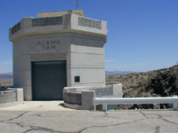
Alamo Dam was constructed by the Corps of Engineers as a multipurpose project under authorization of the Flood Control Act of December 22, 1944 (Public Law 534, 78 th Congress, 2 nd Session). Construction of the 283-feet high earthfill embankment structure began in 1963 and was completed in 1968. The project had a gross storage capacity of about 1 million acre-feet to spillway crest when first completed. Congress authorized the dam with specific storage allocations for flood control, water conservation, and recreation. The outlet works include three large slide gates, which enable a maximum gated release from the dam of 7,000 cfs. A butterfly valve provides the capability to make small releases less than 80 cfs. The spillway is a detached broadcrested weir consisting of an unlined trapezoidal section cut through a rock saddle located in the right abutment. The Alamo Dam Water Control Manual provides detailed information regarding the dam and its operation.
The Alamo Wildlife Area and Alamo Lake, which the wildlife area largely encircles, occupy the area from approximately the confluence of the Big Sandy and Santa Maria Rivers down to slightly below Alamo Dam. The Alamo Wildlife Area was created under provisions of the Fish and Wildlife Coordination Act, and the Arizona Game and Fish Department holds a license agreement with the U.S. Army Corps of Engineers for managing this nearly 20,000-acre area for fish and wildlife conservation purposes. The Alamo Wildlife Area provides the public with many outdoor recreation opportunities and provides habitat for a diversity of fish and wildlife, including game and non-game species.
Human use is minimal along the Bill Williams River corridor. Although extensive alfalfa farming and associated ground-water pumping occurred within the Planet Basin historically and as recently as the early 1990's, agriculture is currently limited to a single cotton farm along a 1.6 mile reach of the river. Recreational use of the river, however, is extensive. Sport fishing, hunting, wildlife watching, and camping are popular activities along the river corridor at the Alamo Wildlife Area, Bill Williams NWR, and Alamo Lake State Park. On the BWR, cattle legally graze only a small area within the Planet Valley, though trespass cattle have utilized several reaches of the river upstream of the Planet Valley, including the Alamo Wildlife Area above Alamo Dam. Feral burros are present throughout the study area; their grazing and browsing impacts vary from relatively minor to severe at different locations along the river. Four-wheel drive vehicles commonly drive through a four-mile stretch of county road within the bottomland of the Bill Williams River National Wildlife Refuge, and some of these vehicles depart from designated roads onto unroaded portions of the floodplain. Alamo Wildlife Area experiences similar vehicle use.
![]() This site was constructed by the U.S. Geological Survey Fort Collins Science Center
This site was constructed by the U.S. Geological Survey Fort Collins Science Center